Wednesday, September 19, 2012

Trip to Acadia National Park - Day 4 of 4

Our last day in Acadia, for this time. The weather could not have been any better. We couldn't leave without another trip around the loop road so we could stop at some of the places we missed on our first day here.

These next 5 pictures were taken from the overlook by Schooner Head.


These next three pictures show a house on the tip of Schooner Head.
 Location

 location

location!


These next seven photos are from our second visit to Thunder Hole. As you can see, the walkway is open all the way to the bottom since the water was much calmer today. Quite a difference from the first day we were here.


 Air gets trapped in a chamber under the rock which just made gurgling sounds today.


These next four we took from the end of the walkway.


Our next stop was Otter Point, where we took the next 4.


After some relaxing on the rocks at Otter Point, we took a short hike to Otter Cliff, seen in this next photo. To give some size perspective, there are people walking about half way up the cliff, but it's difficult to see them.


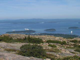
Our last stop before heading home was Cadillac Mountain, a dome of granite with plant life clinging to cracks and crevices. Standing at 1530 feet, it's the highest point in the park. It is also the tallest mountain on the Atlantic coast, north of Brazil. The remaining pictures in this post were taken from there.


 Here you can see three cruise ships docked just off the shore at Bar Harbor.


People can walk from Bar Harbor to Bar Island on this sand bar at low tide. Something to do the next time we visit.

Trip to Acadia National Park - Day 3 of 4

Here are a couple of interesting facts about Acadia National Park. It was established in 1916, the first national park east of the Mississippi. All the land that was joined together to create the park was donated by private citizens.
On this third day our destination was Eastport, Maine, the furthest we could go up the coast without being in Canada.We also went to Lubec to make sure we visited the eastern most point in the US. On our way up, we drove down the Schoodic Peninsula to visit this section of Acadia.

Along the western side of the Schoodic peninsula.


At the top of Schoodic Head, 440 feet.


The light on Mark Island.


The light on Egg Rock.


From Schoodic Point


A lobster fisherman hauling in his catch.


Near Eastport at low tide. You can't really see them here, but there were people way out, digging for clams.


Interesting statue in Eastport


On our way back to Bar Harbor, we took the roads closest to the coast. We see very interesting things this way, like this Navy antenna installation near Cutler.


Trip to Acadia National Park - Day 2 of 4

Our second day we explored some of the less visited areas of Mount Desert Island, where Acadia is located. Most of our day we drove around the western half of the island, stopping at park overlooks and quaint fishing villages.

Village of Southwest Harbor


Acadia National Park - Natural Seawall
 Cobblestone beach


Acadia Bass Harbor Head Lighthouse trail


Unfortunately, they were sandblasting the lighthouse in preparation for painting. So even though it's one of the most photographed lighthouses in Maine, it was not to be for us this time.


Lobster traps on a dock in the village of Bernard


Village of Northeast Harbor


Mount Desert Island is almost split in half by the only fjord on the east coast of the United States. A fjord is a long, deep, and narrow valley cut by glaciers and flooded in by the sea. We enjoyed nice views of Somes Sound while driving on Sargeant Drive.

Somes Sound


A wonderful overlook we stumbled upon and had all to ourselves.


There are almost 100 miles of hiking trails and 45 miles of historic carriage roads in Acadia. We tried a small sampling of each from Jordan Pond.

Jordan Pond


One of the many old stone bridges on the carriage roads.

Trail along the shore of Jordan Pond.